


For more information regarding the value of a property, please contact us for a free consultation.
Key Details
Sold Price $85,000
Property Type Vacant Land
Sub Type Residential
Listing Status Sold
Purchase Type For Sale
MLS Listing ID 795443
Sold Date 04/10/24
Annual Tax Amount $255
Tax Year 2021
Lot Size 5.920 Acres
Acres 5.92
Property Sub-Type Residential
Property Description
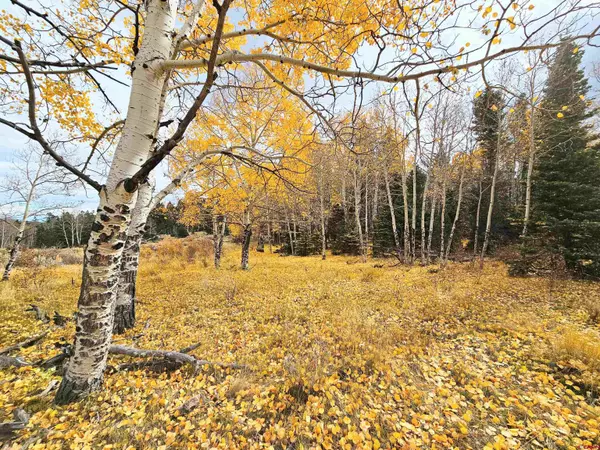
Lot 13A - 5.92 acres accessed from South Rito Hondo Circle. 13A - this lot sits across from 4A and 4B. This is the first lot you come to (on your left) as you're traveling uphill to the 13 series lots. 13 A is heavily wooded and has a slight elevation gain - more pronounced near the front of the lot - which would work well for a walkout basement or a garage under the main part of the home. 13A has good views of Blanca Peak from the front of the lot, and quiet, serene privacy near the back of the lot. Mainly pine and fir trees, lot 13A is quiet and serene. Elecricity to the lot line. Owner financing available. The owners will pay the first $3,000 for the well and septic system. ($1,500 for well, $1,500 for septic.) This subdivision is surrounded by National Forest. The coordinates for lot 13A are :37.01347, -106.21226 HOA Fees are $500 per year. A nearby well (Lot 2) is 400 feet deep and produces 20gpm. Well Permit # 318075. This lot does not have a well already in place, this information is for depth and production reference only. Look for the covenants uploaded to the documents section. There are also virtual tours featuring this lot specifically as well as three fly-over drone videos. LOCATION: The Rito Hondo development is located approximately 10 miles west of Antonito, Colorado, on the south side of Hwy 17. Rito Hondo Club borders U.S. National Forest on all four sides and is roughly 1 mile North of the New Mexico Border in the center of the State. Antonito is 15 minutes by car, while a larger town, Alamosa, is 45 minutes and offers State of the art Medical with a New Hospital and life-flight services. Taos, NM is 1 hour 15 minutes, Santa Fe, NM is 2 hours away. DEEDED ACRES: Rito Hondo, as a whole, is approximately 630 acres M/L. and borders National Forest on all four sides. Several natural, year-round springs are scattered throughout the development, making this a year-round home for a variety of wildlife. TOPOGRAPHY: Each lot is different! Average elevation for the Rito Hondo development is 8,700'. Flat meadows, steep hills, heavy trees, gorgeous views, this development has it all. Describe your favorite environment and we will find you the perfect lot. WILDLIFE: Elk, Deer, birds, all types of small & large game found in Colorado. ACCESS: Year around access of Hwy 17. You'll find paved roads out of Antonito for roughly 8 miles, Well maintained gravel roads for the last 2 miles. VIEWS: Panoramic views in all directions. These are truly spectacular properties with huge views and peace & quiet. IMPROVEMENTS: The development is fully fenced along the exterior where it borders National Forest. Large, ornamental gates secure both the North and South entrances. Excellent gravel roads are in place. Every lot has direct access to a main road except 13-F, which has an easement. Underground electricity is available at each lot line. WATER AND SEWER: Each lot owner will be required to install their own well and septic system. Conejos County does NOT require each septic system to be individually engineered, but they do require a soil test by a licensed contractor. The developers are offering $3,000 for both the well and septic for 35 acre lots (total $6,000), and $1,500 for both the well and septic for 17.5 and 6 acre lots (total $3,000). VEGETATION: Each lot is different, but the development – as a whole – includes stands of ponderosa pine, bristlecone pine, spruce, cedar, pinion, juniper, aspen and cottonwood trees. Lush mountain grass can be found on some of the lower lots near the natural springs. Well permits for properties under 35 acres are under review by the Colorado Division of Water Resources. For more information, please contact Kip with the Colorado Division of Water Resources at ext. 3105.
Location
State CO
County Conejos
Zoning Residential Single Family
Rooms
Dining Room No
Exterior
Utilities Available Electricity Near
View Mountains, Valley
Building
Sewer None
Water None
Schools
Elementary Schools Open Enrollment
Middle Schools Antonito 7-8
High Schools Antonito 9-12
Read Less Info
Want to know what your home might be worth? Contact us for a FREE valuation!

Our team is ready to help you sell your home for the highest possible price ASAP